Copernicus Marine Service Arctic MFC: Validation of mixed layer depth
NOTE! This monitoring was tailored for the BGC product, which preceeded the PHYS-V3 product from TOPAZ5. The validation of mixed layer depth is now incorporated in the general evaluation of the vertical T, S profiles from TOPAZ5, available here.
Computation of anomaly correlations include use of monthly depth interval (layer) climatologies. These were derived from the World Ocean Atlas data.
Validation based on data from profiling buoys
Validation of the Copernicus Marine Arctic MFC results for ocean mixed layer depth is performed using data from profiling buoys, which are compiled by the Copernicus Marine In Situ TAC. New sets of buoy data are available daily, while each buoy provides one profile for each 10-day period. The data are available from Argo buoys, with most buoys covering a depth range of 0-2000 m. Read more about the Argo project here.
Bias is defined as averages of model values - observed values.
CTD data are downloaded from the Copernicus Marine product INSITU_ARC_PHYBGCWAV_MYNRT_013_031.
Regions

|
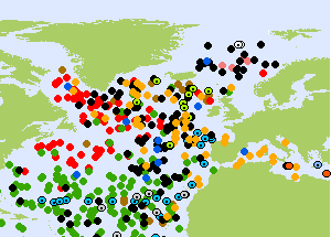
The ocean circulation model used in Copernicus Marine Arctic MFC covers the Arctic Ocean, the North Atlantic Ocean and adjacent ocean regions. The northern part is depicted in the figure to the left. Validation of mixed layer depth from model results are performed for two domains:
However, note that there are rarely any ARGO profile data north of the Nordic Seas, so almost all ARGO observations are either inside of the green region, or in the North Atlantic Ocean and the Labrador Sea (the part of the blue region to the south and to the west of the Nordic Seas). A sample map of the distribution of ARGO profiles (right) illustrates this limitation. |
|
TOPAZ5
The model results are produced with the TOPAZ5 ocean model system. Presently, TOPAZ5 results are updated daily. TOPAZ5 is developed and maintained by the Nansen Center.
TOPAZ5 results for mixed layer depth is not yet available from the Copernicus Marine Service, but can be accessed from a thredds server.
